Orca, a brand-new Norwegian startup, just introduced its new wireless navigation system that is designed to become your “marine co-pilot.” A combination of hardware and software, Orca is organized around a built-from-scratch interface that is meant to make your cruising life safer, easier and more up-to-date.
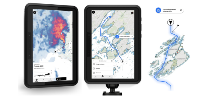
Orca’s founders say they started with a blank slate to rethink the entire design of marine electronics, looking for an iPhone moment. They ended up with a system that includes a rugged tablet from Samsung, a mounting arm, an interface for quick attachment and charging, and an Orca Core computing base unit that connects to the boat’s own sensors, such as sonar and GPS, over NMEA 200 protocols. The sensor data is broadcast wirelessly so you can use it on your tablet or on the Orca nav display.
They built Orca as a modern mobile app with all the connections you’d expect, but all in one place, and reporting data in real time. The routing is instantaneous and accurate, with maps as clear as those on Google and Apple Maps, except they are nautical charts. Weather and tide reports are integrated in to the system; so is marine traffic via AIS.
The system runs on Android or IOS, so you can use your phone to send routes or places of interest to the main unit. But then the system tracks range, weather and traffic and provides the real-time information you need as things change.
In addition to the usual range and bearing updates, Orca delivers fast automatic routing, chart updates and weather forecasts. The screen will be updated to report, “moderate rainfall in 45 minutes,” for example, or “wind increase to 12 mph in one hour.” It also reports on the boat’s systems, from fuel capacity to range and battery status.
Orca features cloud synchronization, so all devices sync automatically. It works even when you’re offshore and without cell reception. Read more at http://getorca.com and see the video below:
