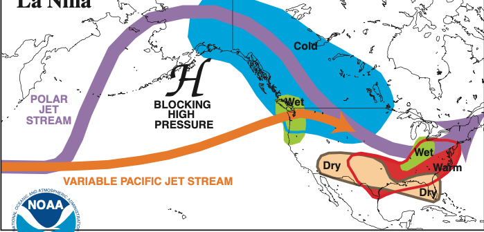
La Niña, the temporary cooling of waters in the central Pacific that has the greatest influence on weather in the Northern Hemisphere, lives on, and on, and on.
Indeed, the world’s leading meteorologists just predicted that La Niña will enjoy a “triple dip” this year, making it the first time this century when it will persist for three straight winters here. “It is exceptional to have three consecutive years with a La Niña event,” said Petteri Taalas, secretary general of the UN’s World Meteorological Organization. “Its cooling influence is temporarily slowing the rise in global temperatures, but it will not halt or reverse the long-term warming trend.”
U.S. forecasters at the Climate Prediction Center say there’s a 91 chance of La Niña continuing through the Northern Hemisphere from September through November, and a 54 percent of it lasting from January through March.
A La Niña winter in the U.S. brings cold and snow to the Northwest, and unusually dry conditions to the southern tier. The Southeast and Mid-Atlantic regions tend to have warmer than average temperatures, but New England and the Upper Midwest suffer through colder than average temperatures.
La Niña is the opposite of El Niño, when waters in the central Pacific are warmer than usual. It is the main driver of weather in the U.S. and around the world, particularly in late fall, winter, and early spring.
La Niña means little girl; El Niño means little boy. The use of those terms as weather designations dates to the 1600s, when South American fishermen first noticed periods of unusually warm water in the Pacific. During La Niña events, the trade winds are stronger than usual, bringing cold, nutrient-rich water to the surface off the West Coast of the U.S. Read more:
https://www.cpc.ncep.noaa.gov/products/analysis_monitoring/enso_advisory/ensodisc.shtml


