

C-MAP just announced that it has updated its charts for North American with enhanced images and more detailed information.
Founded in 1985, C-MAP has become a leader in digital marine cartography and cloud-based mapping. Its C-MAP App makes planning and navigating simple and easy. It’s made for your smart phone, tablet or personal computer, and you can personalize a chart with the layers you want and view it any time you want in the palm of your hand. You also can check the weather, create your own route, or rely on C-MAP’s Autorouting to do it for you.
Now, the new updates will make all that easier, and more reliable. The new data includes better satellite images for 19 states, including North and South Carolina, Rhode Island, and Washington. The company’s exclusive and popular shaded relief features have been added to charts of 500 lakes, including the Great Lakes, coastal areas all the way out to the Bahamas, and as far apart as the Florida Keys and San Francisco.
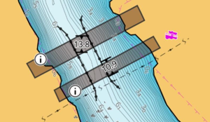
Of particular interest to boat owners in Florida or anyone contemplating the Great Loop, the new updates include detailed information about 13,000 bridges, with enhanced geometry and positioning. And there are new listings of vertical and horizontal clearances for more than 6,400 bridges. C-MAP also has improved its charts for navigable locks, with more accurate geometry and positioning.
Read more at http://c-map.com and see the video below:


