Do you recognize these hazards to safe navigation? Here’s some great advice from Skipper Tips about how to recognize underwater objects that could sink your boat:
Can you look at a paper or electronic navigational chart and identify dangerous submerged piles, posts, or stakes? Hazards like these can damage your costly hull, keel, rudder, or propeller. Use these navigation tips for safer sailing worldwide.
Look to Section K in Chart No. 1 to know what these symbols and abbreviations look like on your chart. This vital section deals with Rocks, Wrecks, Obstructions and Aquaculture. And indeed, dangers like these are considered obstructions.
Download a free copy of Chart No.1 from the National Oceanic and Atmospheric Administration. Save it to your desktop, tablet or phone. I recommend buying a paper copy of this navigator’s dictionary to carry aboard and stowing it in your chart table or beneath a berth cushion, ready to use in an instant.
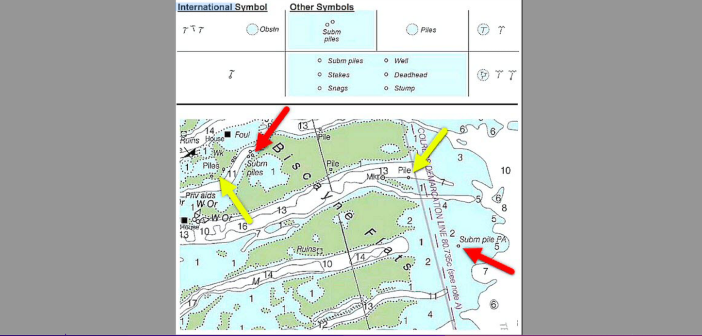
The first column (top illustration) shows the international symbol for obstructions, which is either a squiggly horizontal line with a vertical line beneath or dots which surround a blue-tinted area. The squiggly line represents the sea surface. The vertical line beneath represents the submerged pile, post or stake.
The second column shows some of the more common symbol modifications used on today’s charts. These may be slightly different than those in the first column. Note how the symbol description is written to the right or just below the symbol.
The third column shows symbols which may be found on older charts or on charts used in remote or less developed areas of the world. Look to the third column, only if you are unable to match the symbol to the first or second columns.
On the chart in Florida (above illustration), depths are shown in feet at mean lower low water (MLLW). Colors provide more information about depths, white for deeper water, blue for shallower water and green for inter-tidal areas which cover and uncover with the tide.
Red arrows highlight those pilings which are submerged, or underwater at all stages of the tide. Note that on paper or raster charts (electronic snapshots of a paper chart), these descriptions begin with the abbreviation ‘Subm’ (submerged).
Also, notice how all letters in the description are slanted, which means the object shown is affected in some way by wind, tide, current, or swell. In this case, submerged objects are covered or submerged at both low and high tide, thus the slanted lettering. The abbreviation PA means Position Approximate. Sail clear of any symbol which shows PA in the description.
Yellow arrows highlight those pilings which are always visible, even at high tide. Note that on paper or raster charts, vertical letters indicate an object or land feature which is “always dry”, or visible, even at the high tide levels. Slanted lettering shows objects or seabed sediment which can change with tide, current, wind, etc.
Read more: http://skippertips.com


