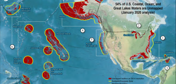
NOAA just released its first report on its progress in mapping U.S. waters, and the results are startling: About 54 per cent of the U.S. coastal, ocean and Great Lakes water are still not mapped.
The report is called Unmapped U.S. Waters and it includes the colorful graphics above, showing areas that have been mapped – and those that haven’t. It created the report from an analysis of publicly available bathymetry.
The percentage of unmapped U.S. waters as of 2019:
U.S. total: 54 per cent.
Atlantic and Gulf of Mexico: 43 per cent.
Great Lakes: 95 per cent.
Caribbean: 42 per cent.
Alaska: 72 per cent.
Pacific (California, Oregon, Washington): 24 per cent.
Pacific Remote Islands and Hawaii: 50 per cent.
NOAA says that multi-beam and lidar surveys are the two primary sources of bathymetry needed to map these areas. It will update the report each year, based on a 2019 Presidential Memorandum that makes comprehensive ocean mapping a priority for the coming decade.
Partnerships and technology will help fill the gaps as the mapping continues, NOAA says. It urges other agencies – hydrographic offices, academic and research institutions – to contribute to this effort as well as private and public vessels.
“Crowdsourced bathymetry is the collection of depth measurements from vessels with standard navigation instruments during routine maritime operations,” NOAA said. “It is a powerful source of information that helps to fill gaps where data is sparse, especially in places where government survey vessels do not have the resources to go in the next ten years.” Read more:
https://iocm.noaa.gov/seabed-2030/mapping-progress-report2020.pdf
