

Here’s some great advice from Skipper Tips about how to use contour lines on land to help you navigate, either when coastal cruising or when making a landfall:
Think of land elevation contours like those found in water–depth contours. Cartographers will sometimes indicate the height of a contour prominent enough to be sighted by a mariner. Heights will be shown as a number, so always check the chart datum to understand the height value. It could be in feet or meters. Make this your first step so that you know at-a-glance what the height values indicate.
1. Why Stagger Contour Lines Elevations?

2. Look for These “Spot Heights” of Navigation Gold!
Just those specific aids with a high degree of survey position accuracy receive a black dot, called a “spot height.”
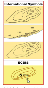
Note the spot heights that show mountain peaks on the first two illustrations below. Use these gold mines for lines of position, radar targets for circles of positions, or waypoints to help you confirm landfall on any coastline.
Exercise caution with any chart symbol that shows broken contour lines (third illustration). Dashed, broken lines mean “approximate” or incomplete survey. Use solid, unbroken lines for more reliability.
3. Electronic Displays of Contours.
Big ships like tankers and freighters will often have electronic charts that comply with the Electronic Chart Display Information System (ECDIS). ECDIS compliant electronic chart symbols represent the highest standards in the industry.
Find all ECDIS symbols and abbreviations in the latest free edition of US Chart No. 1: Symbols, Abbreviations and Terms Used on Paper and Electronic Navigational Charts. You can download a free copy of this nautical treasure from the National Oceanic and Atmospheric Administration here: Chart No.1
Electronic symbols used on recreation vessel displays may be different than those used aboard commercial vessels. Check your electronic chart plotter manual to find out those specific symbols used by your manufacturer.
In the lower illustration, you see the ECDIS compliant electronic display of elevation contours along with a sample spot height (109 meters).
Move the cursor over or near the spot and the height will display as shown. Also notice that the symbol for the spot height appears as a small circle with a bold outline (nautical charts always display a single dot for spot heights). Read more:
https://www.skippertips.com/public/2504.cfm


