Browsing: navigation

Electronics
By

Furuno Unveils MFDs Using AI for Routes

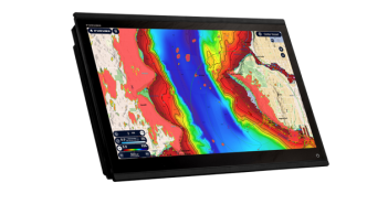
Furuno has unveiled a new series of MFDs that feature AI-assisted routing to take you on the best, safest and most direct path to your destination. And if an obstacle appears along the way, Furuno’s AI Routing will create a new route around it in real time. The new AI feature is part of Furuno’s new NavNet TZtouchXL series of multi-function devices designed for the helm of cruising powerboats. The AI routing uses Furuno’s new TZ maps to create routes along channels and to inlets and marina entrances using the draft of your boat, chart data and other safety parameters.…

Cruising Life
By

How To Avoid Underwater Hazards

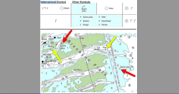
Do you recognize these hazards to safe navigation? Here’s some great advice from Skipper Tips about how to recognize underwater objects that could sink your boat: Can you look at a paper or electronic navigational chart and identify dangerous submerged piles, posts, or stakes? Hazards like these can damage your costly hull, keel, rudder, or propeller. Use these navigation tips for safer sailing worldwide. Look to Section K in Chart No. 1 to know what these symbols and abbreviations look like on your chart. This vital section deals with Rocks, Wrecks, Obstructions and Aquaculture. And indeed, dangers like these are…

Cruising Life
By

C-MAP Updates Charts for North America

C-MAP just announced that it has updated its charts for North American with enhanced images and more detailed information. Founded in 1985, C-MAP has become a leader in digital marine cartography and cloud-based mapping. Its C-MAP App makes planning and navigating simple and easy. It’s made for your smart phone, tablet or personal computer, and you can personalize a chart with the layers you want and view it any time you want in the palm of your hand. You also can check the weather, create your own route, or rely on C-MAP’s Autorouting to do it for you. Now, the…

Cruising Life
By

How To Use Nav Aid Sound Signals

Here’s some great advice from Skipper Tips that could help you navigate safely in fog or reduced visibility:  Imagine you’re cruising on a fogbound coast in New England, the Great Lakes or the West Coast. You see a note on your chart that tells you that you can trigger a fog signal on a lighthouse nearby. Follow these three easy steps. Mariner Radio Activated Sound Signals (MRASS) gives the skipper more control over aids to navigation fog signals. If you see the chart abbreviation MRASS in the description of an aid, you can use your radio to trigger the sound…

Electronics
By

Simrad Unveils New ULTRAWIDE Displays

Simrad just introduced its new NSX ULTRAWIDE MFD that it says is the world’s first ultramarine display with all the features. Simrad says the new display has all the benefits of dual screens in one place, and is 63 percent wider than previous models. The NSX ULTRAWIDE results in an elevated-dash look that offers easier, faster and more efficient installation for OEM or existing boat owners with fewer cables and less set up. It is available in 12-inch and 15-inch screen sizes. The ULTRAWIDE will make its first appearance at the Düsseldorf show, starting Jan. 20, and in the U.S.…

Cruising Life
By

How To Find Your Distance from a Landfall

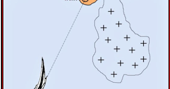
You’re coming into a harbor and your electronics aren’t working (believe me, it happens). You need to figure out how far away you are from making a landfall. Here is some great advice from Skipper Tips about how to figure this out on your own: In a pitch black night, you squint through the binoculars to try to pick up Libby Island lighthouse off the rugged coastline of Maine. The nautical GPS shows you dead on track and the light should be visible from 18 miles (note the abbreviation 18M). Right now, you estimate you are just about 18 nautical…

Cruising Life
By

How To Use RACONs for Coastal Cruising

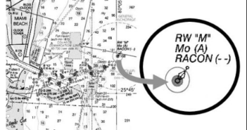
Here’s some great advice from Skipper Tipsabout how to use RACONs to help you navigate safely when you’re cruising along the coast: Imagine you are approaching the busy port of Miami on a pitch black night, in blustery winds and a choppy sea. When still 6 miles away, you turn on your radar and see a cluster of buoys, beacons, and vessels, and each target appears as a separate dot on the radar scope. Your eyes strain with fatigue as you scan the cluster of contacts, trying to pick out the Miami sea buoy, marking the entrance to the harbor.…

Cruising Life
By

7 Tips for Safe Coastal Navigation

Here are seven tips about how to prepare for your next cruise, even before you leave home, from Skipper Tips. Pour yourself a cup of coffee, or whatever, pull out your paper charts (oh, you think your GPS will work all the time?), and get ready for a safe cruise. 1. Mark Shoals and Set the Alarm! Use a dark blue pencil to mark any shoal within one to two miles of your sailing tracks. Set your depth sounder alarm to trigger when you sail within a mile or so of any of these shoals. This will give you more…

Cruising Life
By

How To Use AIS Symbols on Charts

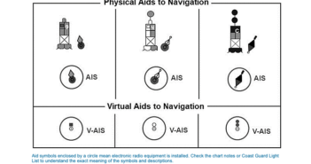
Here’s some great advice from Skipper Tips about how to use AIS symbols on charts to help you cruise safely: Imagine cruising into a new channel, scanning the chart, and finding some buoys have a magenta circle around the buoy symbol. What does this mean, and how can you use these navigation markers to boost cruising safety? Most cruisers already know the value of the Automated Identification System, or AIS, and how it helps prevent collisions at sea. Some buoys and beacons are also equipped with AIS transmitters which give the position, description, and purpose of the aid. Three types…

Cruising Life
By

7 Tips for Safer Coastal Navigation

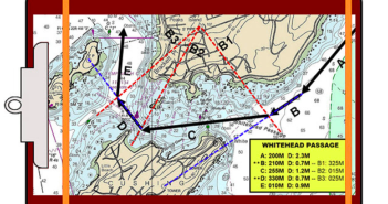
In an age of sophisticated electronics and digital course plotting, it’s all too easy to overlook the basics of coastal navigation. Here are seven tips from Skipper Tips that can serve as a refresher course to keep you and your crew safe on your next cruise: 1. Double-check Courses. Parallel rules and protractors tend to slip when underway. Just a slight bit of slippage could throw a course or bearing off by several degrees. Take the extra step and measure your plotted course twice. If both measurements agree, you will know you’re right! 2. Keep Bearing Spreads to 60-90-120. Shoot two…

1 2 3